You are here
Bureau issues a supplementary Severe Weather Warning for Damaging Winds. 3:54 pm Sunday, 19 June 2016.

TOP PRIORITY FOR IMMEDIATE BROADCAST
SEVERE WEATHER WARNING
for DAMAGING WINDS
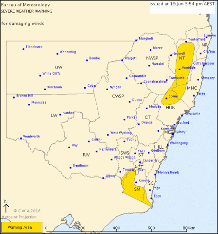
For people in the Snowy Mountains and parts of the Mid North Coast, Hunter, South Coast, South West Slopes, Australian Capital Territory and Northern Tablelands Forecast Districts.
Issued at 3:54 pm Sunday, 19 June 2016.
DAMAGING WINDS SOME NSW RANGES MONDAY
SYNOPTIC SITUATION:
A low pressure system expected to develop off the Illawarra coast tonight should move quickly south and deepen over eastern Bass Strait Monday morning. A vigorous westerly airstream is likely over New South Wales on Monday.
DAMAGING WINDS, averaging 60 to 65 km/h with peak gusts in excess of 90 km/h are possible over higher parts of the ranges in the south and north from Monday afternoon.
Locations which may be affected include Scone, Armidale, Glen Innes, Bombala, Nimmitabel and Khancoban.
The State Emergency Service advises that people should:
* Move vehicles under cover or away from trees.
* Secure or put away loose items around your house, yard and balcony.
* Keep at least 8 metres away from fallen power lines or objects that may be energised, such as fences.
* Report fallen power lines to either Ausgrid on 131 388, or Endeavour Energy on 131 003 or Essential Energy on 132 080, as shown on your power bill.
* For emergency help in floods and storms, ring your local SES Unit on 132 500.
The next warning is due to be issued by 10:55 pm.