You are here
Melbourne Tornado Warning Cancelled - Severe Storms Remain.

**VIC MELBOURNE SITUATION UPDATE**
**NO FURTHER REPORTS OF TORNADOES**
TOP PRIORITY FOR IMMEDIATE BROADCAST
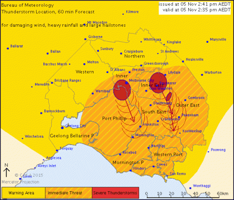
SEVERE THUNDERSTORM WARNING - MELBOURNE AREA
for DAMAGING WIND, HEAVY RAINFALL and LARGE HAILSTONES
For people in the Port Phillip, Western Port, Inner East, Mornington Peninsula, Inner, South East, Outer East and parts of the Western and Geelong and Bellarine Peninsula Local Warning Areas.
Issued at 2:41 pm Thursday, 5 November 2015.
The Bureau of Meteorology warns that, at 2:35 pm, severe thunderstorms were detected on weather radar near Caulfield, Footscray, Melbourne City and Ringwood. These thunderstorms are moving towards the south to southeast. They are forecast to affect Belgrave, Berwick, Mordialloc and Narre Warren by 3:05 pm and Cranbourne, Frankston, Mornington and Pakenham by 3:35 pm.
Damaging winds, heavy rainfall that may lead to flash flooding and large hailstones are likely.
No further reports of tornadoes in past 25 minutes but extensive flash flooding reports northwestern and inner city suburbs.
The State Emergency Service advises that people should:
* Keep clear of fallen power lines.
* secure any loose objects in the vicinity of your home.
* keep away from creeks and drains.
* do not drive vehicles through flooded areas.
* stay indoors if possible.
* Avoid using the phone during the storm.
* if you are outside, avoid sheltering under trees
* listen to the radio for storm updates
* switch off your computer and electrical appliances
The next warning is due to be issued by 3:40 pm.
A more general severe thunderstorm warning is also current for the Central, Northern Country, North Central, North East and parts of the Mallee, South West, West and South Gippsland and Wimmera districts.