You are here
Tornado Alert - Melbourne Area

PLEASE TAKE CARE - SEVERE WEATHER ALERT
MELBOURNE AREA - TORNADOES REPORTED
This Super Cell system is moving towards Port Philip Bay over the next hour!
TOP PRIORITY FOR IMMEDIATE BROADCAST
SEVERE THUNDERSTORM WARNING - MELBOURNE AREA
for DESTRUCTIVE WIND, HEAVY RAINFALL, LARGE HAILSTONES and TORNADOES
For people in the Port Phillip, Inner East, Inner, South East, Western and parts of the Mornington Peninsula, Northern, Outer East and Geelong and Bellarine Peninsula Local Warning Areas.
Issued at 2:01 pm Thursday, 5 November 2015.
THIS INCLUDES A TORNADO WARNING.
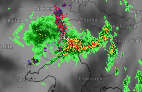
The Bureau of Meteorology warns that, at 1:50 pm, very dangerous thunderstorms were detected on weather radar near Bulla. These thunderstorms are moving towards the south. Very dangerous thunderstorms are forecast to affect Melbourne Airport, St Albans, Sydenham and Williamstown by 2:20 pm and northern Port Phillip Bay, waters off Brighton beach, waters off Pt Cook and waters off Sandringham by 2:50 pm.
Destructive winds, heavy rainfall that may lead to flash flooding, large hailstones and tornadoes are likely.
Several reports of Tornadoes from Craigeburn, Campbellfied and Tullamarine area.
The State Emergency Service advises that people should:
* Keep clear of fallen power lines.
* secure any loose objects in the vicinity of your home.
* keep away from creeks and drains.
* do not drive vehicles through flooded areas.
* stay indoors if possible.
* Avoid using the phone during the storm.
* if you are outside, avoid sheltering under trees
* listen to the radio for storm updates
* switch off your computer and electrical appliances
The next warning is due to be issued by 3:05 pm.
A more general severe thunderstorm warning is also current for the Central, Northern Country, North Central, North East and parts of the Mallee, South West, West and South Gippsland and Wimmera districts.