slideshow 1 slideshow 2 slideshow 3 slideshow 4 slideshow 5 slideshow 6 slideshow 7

MORE POSSIBLE SNOW ON THE WAY

MORE POSSIBLE SNOW ON THE WAY.
Places like Taralga, Crookwell, Orange, Oberon, Armidale, Glen Innes and Guyra could expect at least a dusting of snow to settle by Friday morning with snow expected too fall down to 800m Thursday & in to Friday.
The cold front will bring a pool of cold air behind it this could be some very chilly days for much of NSW.

Western and central NSW could have their coldest days in half a decade on Thursday.

Severe Weather Warning - 3:07pm 10/07/15

Severe Weather Warning
for damaging winds and blizzards
for people in the Hunter, Illawarra, Central Tablelands, Southern Tablelands, Snowy Mountains and Australian Capital Territory forecast districts
Issued at 3:07 pm EST on Friday 10 July 2015.
DAMAGING WINDS. BLIZZARD CONDITIONS ON THE SNOWY MOUNTAINS.
Weather Situation

Mr Cold Front takes a holiday - a children's story

Mr Cold Front takes a holiday - a children's story by Weatherzone.
Bob Neil, Friday July 10, 2015 - 12:57 EST
Once upon a time there was a cold front who lived in the Southern Ocean.

Mr Cold Front was just like any other cold front. He liked to make brief journeys into low latitude countries like Chile, South Africa and New Zealand. It's believed he even owns property in Strahan, Tasmania. He also likes playing cat and mouse with his mate Warmy.

Weekend cold snap for south eastern Australia - BoM

Weekend cold snap for south eastern Australia - BoM
09 July 2015

**COLD SNAP DETAILS**

**COLD SNAP DETAILS**
A powerful cold front will begin to cause showers in the south east of WA on Thursday by Friday a powerful cold front and a pair of troughs one over eastern NSW and the other inland QLD will interact to bring showers and a few thunderstorms across eastern QLD, eastern NSW and VIC.

02/07/15 - Afternoon Update Highlights

02/07/15 - Afternoon Update
*Snowing in Berridale
*Flurries reported in Bombala & Nimmitabel
*Snow at Shooter's Hill.
*111km/h wind gust was recorded with the squally thunderstorms this afternoon on the South Coast at Montague Island.
*Heavy areas of Pea Sized hail reported with the the squally thunderstorms this afternoon on the South Coast around Bodalla & Narooma areas.
*Pea Hail reported (4:15pm) Lake Tabourie.

Hail hits Bodalla, turns road white

Hail turned the Princes Highway white at Bodalla on Thursday, July 2.

Source -

http://www.batemansbaypost.com.au/story/3185913/hail-hits-bodalla-turns-...

Squally Thunderstorms & Damaging Winds - 02/07/15 CANCELLATION

TOP PRIORITY FOR IMMEDIATE BROADCAST

2014/15 Storm Season Intro

View in HD/720p as a Minimum

Well followers, In thank you for sticking with us through this quite time here is a 3:30 minute intro in to some of the 2014/15 storm season as seen through the lens of SSA.
This is just a sample of the footage that will be contained our our up coming DVD & Bluray Discs.
View in HD/720p as a Minimum

Coming Soon!

The 2014/15 season DVD/Bluray

Snow/Hail & Sleet 13/05/15

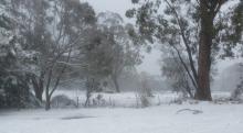
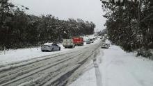
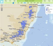
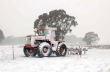
SNOW, Its all about the Snow which has fallen across the Southern Highlands.

Snow has fallen at Wingello, Belanglo and the areas around the Hume Hwy, Breadalbane (between Goulburn and Gunning).

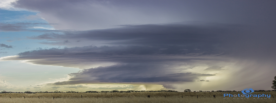
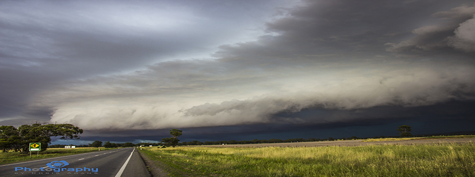
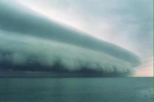
The freezing level is also quite low, at around 1200 meters. Whilst the highest points of the Highlands don't even reach 900 meters, the convective nature of these storms/showers enabled snow to the settle, Snow normally is more likely to settle in the 2 to 4c range.

**BREAKING INFORMATION FOR QLD**

**BREAKING INFORMATION FOR QLD**
Queensland Premier Annastacia Palaszczuk and Police Minister Jo-Ann Miller will hold a media conference at 9.15pm, broadcast live on ABC News 24.

You can view on-line here:
http://iview.abc.net.au/programs/abc-news-24/NS1413V001S00

ECL Update - 01/05/15

A very serious situation is currently occurring in SE QLD and NE NSW.

An East Coast Low developed off the Sunshine Coast several hours ago. As a result winds along the coast have strengthened to gale force, and rainfall has enhanced significantly. To make matters worse, a convergence line established itself just inland from the Brisbane coast. This has destabilized the situation even further leading to torrential rain,and some incredible rain fall rates. Numerous lightning strikes have also occurred in the area over the last hour or two.

Nowra Area - 01/05/15

With 23mm of rain falling in the Nowra area since 9am and receiving 35mm overnight. I thought I would check out the local area.

More rain is forecast, more on that in our update later. Places like Jaspers Brush airfield resemble more a lake with a stunning back drop of Cambewarra Mountain.

East Coast Low Update & Forecast - 30/04/15

I have an East Coast Low update,and forecast for you!
In brief , heavy rain likely for the Sunshine Coast,Brisbane,and Northern Rivers, tonight and tomorrow,as a low develops off the Southern QLD coast. Totals are likely to reach 100-200mms. Lighter more general rain expected further west and south.

Pages