slideshow 1 slideshow 2 slideshow 3 slideshow 4 slideshow 5 slideshow 6 slideshow 7

URGENT EVACUATION NOTICE- Jerrara Dam

URGENT EVACUATION NOTICE
From NSW SES
URGENT EVACUATION NOTICE- Jerrara Dam, ‪#‎Kiama‬ residents living downstream of the dam need to take action and evacuate immediately.
The dam is failing ‪#‎Evacuate‬ now. For info listen to your local radio. Visit the NSW SES website for further information http://bit.ly/1JfYi1D
An ‪#‎emergencyalert‬ has gone out to people with properties in the area shown below:

FLOOD RESCUES IN NORTHERN ILLAWARRA

FLOOD RESCUES IN NORTHERN SUBURBS

NSW SES volunteers have been called to rescue multiple people trapped in their vehicles in Thirroul and Woonona.

NEVER ENTER FLOODWATERS

Rain Totals (greater than 20mm) to 9:00am 25/8/15

Rain totals for 9am 24/8 to 9am 25/8 above 20mm
(For Sydney/Illawarra/South Coast)
I hope Bellambi has a pair of floaties! Nowra too!
Badgerys Creek 31.6mm
Bankstown 27.2mm
Camden 37.2mm
Campbelltown 47.4mm
Canterbury 45.6mm
Holsworthy 35.4mm
Horsley Park 31.2mm
Lucas Heights 52.1mm
Penrith 26.4mm
Sydney Airport 43.6mm
Sydney Obs Hill 54.5mm
Sydney Olympic Park 24.2mm
Terrey Hills 25.8mm
Albion Park 159.2mm
Bellambi 192.0mm
High Range (Wanganderry) 63.2mm
Kiama 170.4mm

A Tornado makes an Appearance in Dubbo NSW

Again please ignore the media as there is no such thing as a mini tornado, This was the real thing a Tornado which caused damage to properties in that area.
This is not uncommon in NSW, you can find out more about Tornadoes in Australia on our website:
http://www.stormspottersaustralia.com.au/site/?q=node/1

Roads Update - 8:00pm

ROADS UPDATE - 8:00PM 24/08/15
**Reports of water of roads in the Southern Illawarra, Please take care.**
Grenfell Henry Lawson Way at Mid Western Hwy
FLOODING
Started today 7:49pm
Impact: Impact Traffic affected in both directions.
Attending: Local council
Advice: Exercise caution
Batlow Batlow Rd at 6km North Of Batlow
HAZARD Fallen tree
Started today 7:48pm
Impact: Impact Traffic affected in both directions.
Attending: Local council
Advice: Exercise caution

Heads Up - Southern Highlands - 3:00pm CANCELLED 24/08/15

CANCELLED

*Heads Up* - 2:45PM
A small multi cell thunderstorm complex is currently in the Southern Highlands area heading towards High Range and affecting that general area over the next 30mins

Clear Air Lighting is associated with this thunderstorm complex. Hail is VERY likely.
Please heed caution in that area.

NSW Flood Watch - 24/08/15

FLOOD WATCH FOR ILLAWARRA, SOUTH COAST AND THE LACHLAN AND NEPEAN RIVER VALLEYS

Issued at 12:54 pm EST on Monday 24 August 2015
##

Note: This Flood Watch provides early advice for possible future flooding along all rivers, creeks and overland flow paths within a nominated valley [See note below].

Severe Thunderstorms Blanket Eastern NSW

Isolated Severe Thunderstorms are still cropping up all over the place I have highlighted some of these to keep an eye on.

Image: Thanks to Weatherzone.

CANCELLATION DETAILED SEVERE THUNDERSTORM WARNING - NSW

TOP PRIORITY FOR IMMEDIATE BROADCAST

CANCELLATION DETAILED SEVERE THUNDERSTORM WARNING
Issued at 12:31 pm Monday, 24 August 2015.
Severe thunderstorms are no longer affecting Sydney Newcastle Wollongong or surrounding areas. The immediate threat of severe thunderstorms has passed, but the situation will continue to be monitored and further warnings will be issued if necessary.

Hail the size of 2 dollar coins was reported at Oberon at 11:30am.

Morning Thunderstorm Update - 24/0815

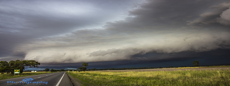
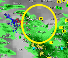
Good Morning, A complex of thunderstorms have been moving east from out west towards to NSW coast, heading for the Southern Highlands and Illawarra region in particular.

That general area could see falls of around 25-50mm by Tuesday with possible local heavy falls which could lead to flash flooding under thunderstorms.

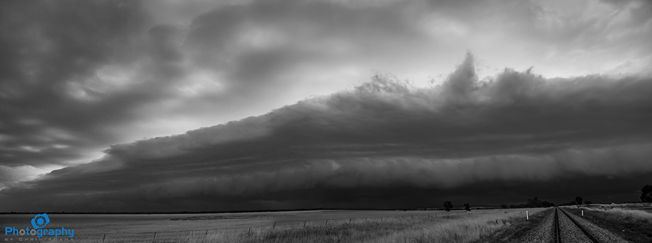
No really photography thunderstorm wise today and the complex is very rain wrapped but the rumbles of thunderstorm will grace us for much of the afternoon.

Winds are averaging around 30km/h with this system but stronger gusts again for possible.

SE QLD CANCELLATION SEVERE THUNDERSTORM WARNING

TOP PRIORITY FOR IMMEDIATE BROADCAST

CANCELLATION SEVERE THUNDERSTORM WARNING - SOUTHEAST QUEENSLAND
Issued at 5:52 pm Wednesday, 12 August 2015.
Severe thunderstorms are no longer affecting the Southeast Queensland area (east of Dalby from Rainbow Beach to Stanthorpe). The immediate threat of severe thunderstorms has passed, but the situation will continue to be monitored and further warnings will be issued if necessary.

Snow/Cold Update - 12/08/15 3:00pm

**WEATHER UPDATE**

At time of writing (2:50pm) Bathurst was under siege by small hall generated by a cold air thunderstorm in the area.

Mean while snow has made a come back to the Central Tablelands for the 5th time this winter.

Snow has fallen in Canberra's CBD, Orange, Oberon, Millthorpe and Blayney. Though the snow is falling we will struggle to see accumulation above 1cm in most of these places, Snow chances remain until tonight.

SNOW & ICE ROAD CONDITIONS - Updated 10:00pm

**SNOW & ICE ROAD CONDITIONS** Updated 10:00pm ROADS CLOSED

BATLOW Batlow Rd
ALPINE CONDITIONS Snow
Started today 11:32am, last checked today 9:48pm
Impact: Impact Traffic affected in both directions.
Attending: Local council
Advice: Exercise caution
Reduce speed

MEDLOW BATH Great Western Hwy
ALPINE CONDITIONS Snow and ice
Started today 4:44pm, last checked today 9:48pm
Impact: Impact Traffic affected in both directions.
Advice: Reduce speed
Exercise caution

**COLD WEATHER ON THE WAY**

**COLD WEATHER ON THE WAY**

A strong cold front is currently storming its way across South Australia brining winds of 78km/h which were recorded at Ceduna SA.

Scattered thunderstorms are also associated with this front which is expected to begin moving in to Western NSW overnight (Tuesday in to Wednesday) before crossing the Southern Tablelands/Highlands around in the 3-7pm bracket.

The Sun is out but not for long...

Sunny weather is set to greet us for a couple of days but make the most of it as a broad low pressure trough will trigger showers from Queensland to Victoria come Wednesday.

This will clear Thursday apart from some coastal hit and miss showers before again things raping up Friday with rain and possible thundery shower activity for much of NSW, VIC, TAS and Southern QLD.
More details about Wednesday tomorrow and Friday's event Thursday.

Pages