You are here
Potential ECL to bring Wind & Rain with Large Surf.

The Bureau of Meteorology has released a warning included below of the up and coming Severe weather to affect parts of the Queensland coast and NSW coast. NE NSW is set to bare the brunt easing the further south you go.
As is typical of a East Coast Low event it will depend very much on where the low forms as too who gets the most rainfall and wind. 24 hour totals of in excess of 100 mm are possible, with winds up to 100km/h.
Details of the warning are below:
**NSW**
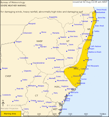
TOP PRIORITY FOR IMMEDIATE BROADCAST
SEVERE WEATHER WARNING
for DAMAGING WINDS, HEAVY RAINFALL, ABNORMALLY HIGH TIDES and DAMAGING SURF
For people in the
Mid North Coast and parts of the
Northern Rivers Forecast Districts.
Issued at 11:05 am Tuesday, 2 August 2016.
HEAVY RAIN, VERY WINDY AND LARGE WAVES ON NSW NORTH COAST ON WEDNESDAY
SYNOPTIC SITUATION:
A cold front will move through northeastern New South Wales Tuesday night and as it moves offshore a low is expected to develop off the far north coast during Wednesday morning.
HEAVY RAIN which may lead to FLASH FLOODING is likely to develop in the southern parts of the Mid North Coast district early Wednesday and extend to the northern parts by the afternoon. 24 hour totals of in excess of 100 mm are possible.
DAMAGING WINDS, averaging 60 to 70 km/h with peak gusts in excess of 90 km/h are possible along the coastal fringe of the Mid North Coast and Northern Rivers districts during Wednesday.
ABNORMALLY HIGH TIDES which may cause sea water flooding of low lying areas are expected on the Mid North Coast Wednesday night. Water levels could exceed the highest tide of the year during Wednesday evening high tide at around 9pm.
VERY HEAVY SURF which may lead to localised damage and coastal erosion is possible on Wednesday on Mid North Coast and Northern Rivers districts, particularly on south facing beaches.
Beach conditions in these areas could be dangerous and people should stay well away from the surf and surf exposed areas.
Locations which may be affected include Coffs Harbour, Port Macquarie, Taree, Woolgoolga, Sawtell and Dorrigo.
The State Emergency Service advises that people should:
* Move vehicles under cover or away from trees.
* Secure or put away loose items around your house, yard and balcony.
* Keep at least 8 metres away from fallen power lines or objects that may be energised, such as fences.
* Report fallen power lines to either Ausgrid on 131 388, or Endeavour Energy on 131 003 or Essential Energy on 132 080, as shown on your power bill.
* Don't drive, ride or walk through flood water.
* Keep clear of creeks and storm drains.
* If you are trapped by flash flooding, seek refuge in the highest available place and ring 000 if you need rescue.
* For emergency help in floods and storms, ring your local SES Unit on 132 500.
The next warning is due to be issued by 6:05 pm.