You are here
SE QLD Thunderstorm Upgraded to VERY DANGEROUS - BoM Warns, 4:58 pm Sunday, 19 June 2016.

**SE QLD UPDATE**
TOP PRIORITY FOR IMMEDIATE BROADCAST
SEVERE THUNDERSTORM WARNING - SOUTHEAST QUEENSLAND
for HEAVY RAINFALL
For people in the Logan and parts of the Ipswich, Scenic Rim, Brisbane City and Moreton Bay Council Areas.
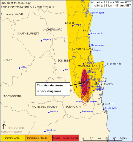
Issued at 4:58 pm Sunday, 19 June 2016.
The Bureau of Meteorology warns that, at 4:35 pm, very dangerous thunderstorms were detected on weather radar near Brisbane CBD and Strathpine. These thunderstorms are slow moving. Very dangerous thunderstorms are forecast to affect Sunnybank Hills, Camp Hill and Narangba by 5:05 pm and Beaudesert, Lake Samsonvale and Burpengary by 5:35 pm.
Heavy rainfall that may lead to flash flooding is likely.
Kenmore has recorded 68mm in 1 hour.
Greenhill has recorded 65mm in 1 hour.
Queensland Fire and Emergency Services advises that people should:
* Never drive, walk or ride through flood waters. If it's flooded, forget it.
* Seek shelter, preferably indoors and never under trees.
* Avoid using the telephone during a thunderstorm.
* Beware of fallen trees and powerlines.
* For emergency assistance contact the SES on 132 500.
The next warning is due to be issued by 6:00 pm.
A more general severe thunderstorm warning is also current for parts of the Central West, Channel Country, Wide Bay and Burnett, Maranoa and Warrego and Southeast Coast districts.