You are here
CLOUDS! - What are they and how are they formed?
Clouds form when warm air rises and expands and cools forming tiny droplets of water or ice crystals that settle onto dust particles in the atmosphere, the dropletes are so small (a diameter of around 100th of a milimeter), so that means each cubic metre of air will contain 100 million droplets. Clouds will either be composed of either ice or water droplets, depending on the height of the clouds and the temperature of the atmosphere, because the droplets are so small they can remain in liquid form in temps as low as -30C. Extremely high clouds at temps below -30C are composed of ice crystals.
There are several factors which can lead to cloud formation.
1: Surface heating: This is what happens when the ground is heated up by the sun which in turn heats the air that is touching it, making it rise. The coloumns of warm air are often called thermals. Surface heating tends to produce cumulus clouds.
2: Topography (study of surface shape/features): The shape of the land can cause clouds to be formed; when air is forced to rise over a barrier of mountains or hills it cools as it rises, this is usually how layered clouds are formed.
3: Frontal: Frontal clouds are formed when a mass of warm air rises up over a mass of cold dense air over large areas along fronts. A front is the boundary between warm moist air and cooler drier air.
4: Convergence: Streams of air flowing from different directions are made to rise where they flow together, or converge. This can create cumulus and showery conditions.
The range of ways in which clouds can be formed and the variable nature of the atmosphere results in an enormous variety of shapes, sizes and textures of clouds.
Clouds are dictated by the elements that are available - including the amount of water vapor, the temperature at a specific height and wind and interplay of other air masses. Clouds move with the wind, high cirrus clouds are pushed along by the jet stream, sometimes going faster than 160km/h, though when clouds are part of a thunderstorm, their speed is roughly 60km/h.
--------------------
Types of clouds
--------------------
High Clouds = Cirrus [above 18,000ft]. This cloud group includes: Cirrus, Cirrostratus, Cirrocumulus.
Middle Clouds = Alto [6,500ft to 18,000ft].This cloud group includes: Altostratus and Altocumulus.
Low Clouds = Stratus [Upto 6,500ft]. This cloud group includes: Stratus, Stratocumulus and Nimbostratus.
Clouds with vertical growth: Cumulus and Cumulonimbus.
Special clouds: Mammatus, Lenticular, Fog, Contrails, Fractus, Green.
CIRRUS CLOUDS:
------------------------
-Cirrus clouds are the most common of the high clouds, they are composed of ice (due to height) and are thin and wispy blown around by high winds into long streams. They are usually white clouds and are a sign of fair weather.
-Cirrostratus are thin, sheet like high clouds that often cover large parts of the sky. They are usually so thin you can see the sun and moon through them.
-Cirrocumulus appear as small round white puffs in long rows that sometimes resemble fish scales. Cirrocumulus is common in winter and indicate fair but cold weather.
ALTO CLOUDS:
--------------------
-Altostratus clouds are usually grey/blue-grey mid level clouds composed of both water droplets and ice crystals, they usually cover a large part of the sky and often form ahead of storms with rain or snow.
-Altocumulus are mid level clouds that resemble grey puffy masses and usually form in groups and on a warm humid morning are a good sign of thunderstorms late in the day.
STRATUS CLOUDS:
-------------------------
-Stratus clouds are uniform greyish cloud that also cover large parts of the sky, they resemble fog that doesnt reach the ground and sometimes light mist or drizzle falls from this type of cloud.
-Stratocumulus clouds are low, puffy and grey, and you can usually see bits of blue sky in between these puffs.. Rain rarely occurs with stratocumulus, though they can turn into nimbostratus clouds.
-Nimbostratus form as a dark grey, wet looking cloudy layer that is associated with continuous falling rain and usually produce rain that is usually light to moderate.
CUMULUS CLOUDS:
--------------
-Cumulus are white puffy clouds that resemble floating cotton. They're sometimes called 'fair-weather clouds'. The base of cumulus clouds are flat and the top has rounded towers and when the top resembles the head of a cauliflower it is called cumulus congestus or towering cumulus, these clouds grow upward and can develop into giant cumulonimbus clouds, which are thunderstorm clouds.
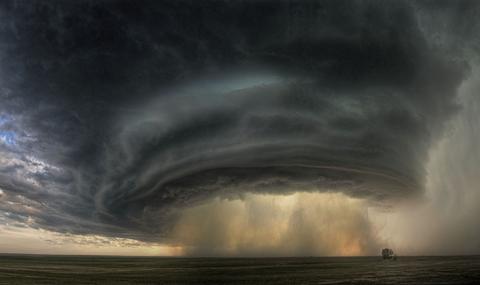
-Cumulonimbus clouds are thunderstorm clouds, high winds can flatten the top into an anvil like shape, and this cloud type is associated with heavy rain, snow, hail, lightning and even tornadoes, the anvil top usually points in the direction the storm is moving.
SPECIAL CLOUDS:
------------------------
-Mammatus clouds are low hanging bulges that drop from cumulonimbus clouds, and are usually associated with severe weather.
-Lenticular clouds are caused by a wave wind pattern created by mountains. They look like discs or flying sauces.
-Fog is cloud on the ground. It's composed of billions of water drop lets floating in the air, it exists if the atmospheric visibility near the Earths surface is reduced to less than a kilometer.
-Contrails are condensation trails behind jet aircraft, and form when hot humid air (like from a jet exhaust) mixes with environmental air of low vapor pressure and low temperature.
-Fractus clouds are small ragged looking cloud fragments that are usually found under an ambient cloud base, they form from or have broken off from a larger cloud and are generally sheared by strong winds, giving them their ragged appearance. This type of cloud has irregular patterns, looking like torn pieces of cotton candy, they change constantly and dissipate rapidly.
-Green clouds are often associated with severe weather, the green colour is not completely understood but is thought to do with having a high amount of liquid water drops and hail inside these clouds.