You are here
Weather Fronts, What are they?

Weather fronts
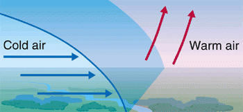
Weather fronts mark the boundary between two air masses, which often have contrasting properties. For example, one air mass may be cold and dry and the other air mass may be relatively warm and moist. These differences produce a reaction in a zone known as a front.
A cold weather front is defined as the changeover region where a cold air mass is replacing a warmer air mass. Cold weather fronts usually move from northwest to southeast. The air behind a cold front is colder and drier than the air in front. When a cold front passes through, temperatures can drop more than 15 degrees within an hour.
On a weather forecast map, a cold front is represented by a solid line with blue triangles along the front pointing towards the warmer air and in the direction of movement.
There is usually an obvious temperature change from one side of a cold front to the other, An abrupt temperature change over a short distance is a good indicator that a front is located somewhere in between.
A warm weather front is defined as the changeover region where a warm air mass is replacing a cold air mass. Warm fronts usually move from southwest to northeast and the air behind a warm front is warmer and moister than the air ahead of it. When a warm front passes, the air becomes noticeably warmer and more humid than it was before.
On a weather forecast map, a warm front is represented by a solid line with red semicircles pointing towards the colder air and in the direction of movement.
Again, there is typically a noticeable temperature change from one side of the warm front to the other, much the same as a cold front.
If colder air is replacing warmer air, it is a cold front, if warmer air is replacing cold air, then it is a warm front.
Here is a great little video to explain weather fronts and what kind of weather do they bring?
Video Credit (metoffice.gov.uk)