You are here
ECL Weather Update Evening - 21/04/15

Today sure has been quite an eye opener in the Storm Chasing community as well as the wider community with this quite significant event bringing sadly high levels of destruction both through wind and flooding.
Earlier today authorities had sent emergency alerts to tens of thousands of people in NSW's Hunter region as wild weather claimed three lives, The NSW Premier Mike Baird said that a state-of-emergency declaration was "under consideration" as well as earlier encouraging people to leave work early to avoid being caught in the deteriorating weather conditions.
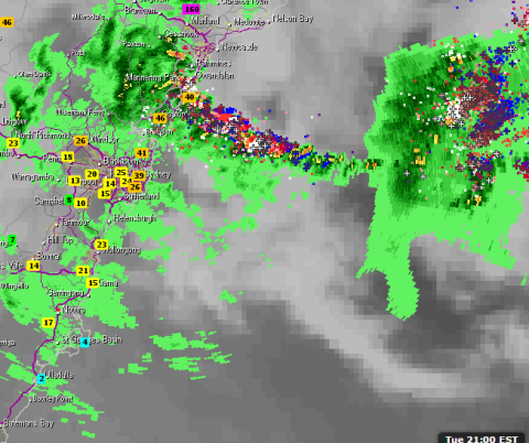
At time of writing the BOM has a Severe Weather Warning for the Metropolitan, Hunter and Illawarra forecast districts for damaging and locally destructive winds, damaging winds, heavy rainfall and damaging surf. This afternoon I was out in the field and done a number of live updates as conditions began to worsen. 95km/h wind guests were recorded at Bellambi in the Illawarra at 8:30pm whilst further north Norah Head has pretty much had consistent wind gusts exceeding 100km/h with 135km/h recorded as the highest at present.
The ECL is expect to slowly move south however it will slowly weaken as it does so, Conditions are expected to slowly ease during Wednesday.
Another factor that is set to cause a little alarm is the fact that high tide is yet to come high tide tonight will be about 10.30pm. Yesterday's storm surge took it up to 2.13m.
There continues to be massive disruptions to power and the public transport network.
Severe Weather Information: (correct as at 8:26pm)
DESTRUCTIVE WINDS averaging 90 to 100 km/h with peak gusts to 125 km/h are forecast for coastal parts of the Hunter district (including the Central Coast) tonight and early Wednesday.
DAMAGING WINDS averaging 60 to 70 km/h with gusts to 100 km/h are forecast for the coastal fringe of the Metropolitan and Illawarra forecast districts.
THUNDERSTORMS AND HEAVY RAINFALL is likely in the Hunter district (which includes the Central Coast), the Metropolitan and Illawarra districts.
VERY HEAVY SURF, which may lead to localised damage and coastal erosion, is forecast for the Metropolitan, Hunter and Illawarra forecast districts. Beach conditions in these areas are dangerous and people should stay well away from the surf and surf exposed areas.
Wind gusts to date include: 135 km/h at Norah Head and Nobby's Head, 110 km/h at Williamtown, 107 km/h at Molineaux Point and Sydney Airport.
Rainfall totals from 9am Monday to 9am Tuesday include: 312 mm at Dungog, 259 mm at Crawford (near Bulahdelah), 186 mm at Wallsend, 172 mm at Wahroonga (Sydney).
Rainfall totals from 9am to 8pm today include: Maitland 292 mm, Seaham 152 mm and Tocal 158 mm (all in the Hunter Valley).
Image: Weatherzone