- QLD Flood warning issued at 2:30pm EST
- NSW Coastal wind warning issued at 1:59pm EST
- QLD Flood warning issued at 1:55pm EST
- QLD Flood warning issued at 1:45pm EST
- NSW Flood warning issued at 12:48pm EST
- NSW Flood warning issued at 12:41pm EST
- NSW Flood warning issued at 12:34pm EST
- QLD Flood warning issued at 12:33pm EST
- QLD Flood warning issued at 12:27pm EST
- QLD Flood warning issued at 12:22pm EST
You are here
ECL Weather Update - 21/04/15

Wild weather has battered the NSW coast over the last 24 hours with many areas sustaining flooding and wind damage, There are still thousands of homes without power. Heavy rain and wind gusts in excess of 135 km/h have lead to this weather system being likened to cyclone conditions
The Hunter and Mid North Coast have bore the brunt of these conditions with up to 200mm of rain expect to fall in that area today.
Wind gusts to date include: 135 km/h at Norah Head, 120 km/h at Nobby's Head, 110 km/h at Williamtown, 90 to 100 km/h at North Head, Sydney Airport and a 11 meter wave was recorded by a buoy off Sydney.
At time of writing there are a line of dangerous thunderstorms that are occurring from around Nelson Bay to Maitland in the Hunter Valley, Destructive winds are possible, particularly along the coastal fringe. Heavy rainfall that may lead to flash flooding is possible across the warning area. It is possible that low-lying parts of Newcastle may be significantly impacted during the afternoon.
In the hour to 9:45am Tocal recorded very intense rainfall of 112mm.
The wild weather has also had an impact on the rain network with Train services have been cancelled between Newcastle and Sydney as well as between the Central Coast and Newcastle as well as
services on the South Coast train line have also been cancelled between Oak Flats and Kiama.
There are a large number of flooded roads and other hazard which we suggest you check
https://www.livetraffic.com/desktop.html before your trip though it is advised to postpone road travel especially in the mid north coast/Newcastle area.
We will continue to monitor the situation through today and bring you the latest weather warnings and information.
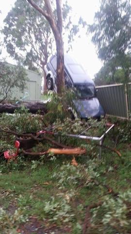
IMAGE - Kurri kurri in the Hunter.