You are here
East Coast Low Update- 20/04/2015
East Coast Low Update- 20/04/2015
Good evening guys,
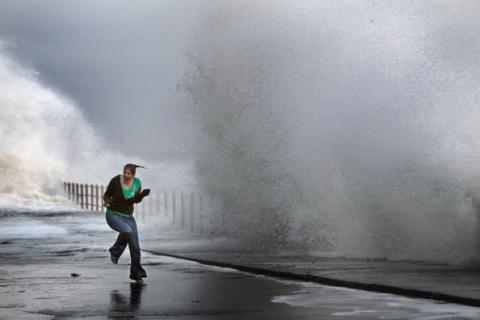
The East Coast of NSW is experiencing wintery conditions today, including heavy rain,some flash flooding, and gale force winds along the coastal fringe. Totals since 9am are currently ranging between 30-70mms along coastal parts, with plenty of 50mm+ totals already being recorded.
The current situation is very dynamic with an East Coast Low expected to develop off the coastline near Newcastle. The low is still in its development stage, however as it winds up most of the heavy rain should contract to the Sydney Basin and northwards, with the Illawarra set to experience a brief reprieve tonight (rainfall wise) . Wind wise, the Illawarra is still under threat with 90-100km/h gusts still possible along the coastal fringe tonight,anywhere north of here may experience even stronger gusts. (Wattamolla has already experienced a gust to 132km/h!)
The heaviest falls over the next 24-36 hours are likely to occur between Newcastle and Forster, with falls approaching 300mms possible for the event. At the moment the heaviest falls are occurring in the Sydney Basin, with some sites experiencing accumulative falls of 15mm/hr. Wollongong and southwards are experiencing easing conditions rainfall wise as mentioned, however frequent showers can still be expected for this region tonight.
Models are hinting that the low will move southwards mid week, possibly bring the heavy showers/rain back to the Illawarra, however placement of the low is critical. Either way we'll monitor the situation.